
The San Francisco Bay Area encompasses many beautiful locations. Although the world famous Golden Gate Bridge is California’s most recognizable landmark symbolizing this area, and perhaps the state in general, the gorgeous nature scenery equally deserves to represent this expansive west coast state. Despite having interconnected urban cities, there are reclusive spots where you can reconnect with Mother Nature on hiking trails. Bear witness to sunsets painting evening skies; nature intermingling with urban borders; redwoods growing high until the eyes can’t distinguish the tops. If you are traveling to the San Francisco Bay Area region, and you’re an outdoor hiking fanatic, then it’s required that you partake in a hiking adventure trip to the five locations described below.
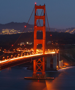
(Image: "Golden Gate Bridge at Night" art print. Click here to buy) Marin Headlands Hiking Trails
The vast ocean intercepts the Golden Gate Bridge. Hear the strong waves brush against the shoreline. Observe the sunlight enshrine Marin valley in golden light. In the distance, you will stare at the mesmerizing presence of the Golden Gate Bridge. You’ll wonder how mere mortals constructed such a behemoth. If you are lucky enough to hike this area around evening, you’ll witness the dancing car lights emanating from Bridge, creating a beautiful light show. Blinking lamps and glowing towers provide the stage. But have your coat or hoodie handy---the weather can change very easily from warm breezes to cold winds.
Muir Woods to Stinson Beach
Imagine damp paradise full of tall redwoods. Your perspective of time will wonder away while you’re staring upwards at these trees. You’ll learn information about the some of the oldest organisms on the planet. As you traverse further, hiking trails will lead you along more nature’s beauty. Then tremendous viewpoints of the Bay Area will open in front of your eyes, revealing sights unimaginable. You’ll walk down a series of steps on the Dipsea trail, but your reward will be visiting one of the best kept secrets of Marin---Stinson Beach. You will discover that small, neighborly towns still exist in America. Relax, eat at the local seafood restaurant, partake in friendly conversations, and then begin the small hiking trek back to Muir Woods.
Angel Island
Angel Island is a mystery to my generation. To older Californians, especially Chinese and other Asian descendants, the location symbolizes one of America’s shameful moments. The detention centers used to house them still exist on the island. Before that time period, the government set up base here to prevent the Confederates from conquering California. After that time period, it becomes a menacing presence during the Cold War---a storage facility for Nike-Ajax missiles. Today, it’s a marvelous island. Beaches, hiking trails, and historical remnants are scattered across Angel Island. Its surrounding waters are a destination for affluent retirees and young partiers from nearby Tiburon. Boats and ferry are the only means of reaching the island.
Tilden Park – Peace Grove
Tilden Park is one of the earliest of the California State Park system. It technically extends from Richmond to Oakland and touches Orinda. It’s apart of the Bay Area Ridge trail that starts from edges of the Delta, circles around the South Bay Area, and ends at the Golden Gate Bridge. One particular spot is popular for sightseers: the Peace Grove. From this location, most of the western East Bay Area (up to the edge of Vallejo) and portions of San Francisco are visible. With clear skies, you can see some landmarks of the South Bay Area. In the evening the moon rises behind Mount Diablo that’s also visible in the background. You are surrounded by green hills. And to think this exact place is invisible from the ground.
Mount Diablo
Finally, I cannot ignore the Bay Area’s largest behemoth: Mount Diablo. This 3800-foot
mountain is a trademark of the eastern East Bay Area, accessible from four different cities--- Clayton, Walnut Creek, Danville, and San Ramon. It’s also the only location where you can find snow in the Bay Area. During the summertime, all kinds of bugs inhabit the grassy fields. At the peak, flying pincher beetles occupy the surroundings. You cannot leave this mountain untouched if you’re an avid hiker. There are numerous ways of hiking Mount Diablo: hike your way to the top by starting from bottom hiking trails, or you can drive to the peak and hike the trails at the top. However, it’s a steep climb either way. My Ford Focus almost slid down the mountain road due to the rapid ascent. I hope you enjoyed this article. If you're addicted to outdoor hiking trips, the San Francisco Bay Area contains many hiking trails that you can enjoy. If you want to read about my Bay Area hiking adventures, click here to visit my blog atOutdoorHikingTrek.com. |
San Luis Obispo BlogRegular WritersSarah Simon AboutWe look to provide ideas to get folks away from the couch, and out exploring California. We aim to provide day-trips. We want to provide suggestions of things to do, in a single day. Whether you're from out-of-town, or looking to get to know the our magnificent section of California (and beyond) a little better....we want to inspire you to explore. Categories
All
|
 RSS Feed