
|
El Chorro Regional Park is located about 3.5 miles north of San Luis Obispo, directly across from Cuesta College. Dairy Creek Golf Course, shares this expansive property which used be grazing land for cows (that's why it's called "Dairy Creek"). Many dairy farms were located in the area, prior to the govenment purchasing the land in the 1940s. Camp San Luis Obispo was created to train soldiers, and used this property to do so, until the Nixon administration in 1972. President Nixon gave the land, that is now El Chorro Park, to San Luis Obispo County. Under county control, the land is used for golfing, camping, events, a botanical garden, sports, and most important to this article....hiking. This hike has a steady incline to it, so you get to the panoramic view quickly. However, the terrain is not so steep that beginers or parents with their kids will have trouble. The quick and easy trek to start seeing the majesty of the surrounding area, makes this a great hike for Cuesta students between classes. In order to find the trailhead, continue to the very last parking lot in El Chorro Park. From there, the pedestrian gate is about .25 miles along the road. The Sierra Club has provided an opportunity to hike a self-guided nature trail at this location. The signs are clearly visible, and you should have no problem following them. Approximately .5 miles up the trail, you will make a right turn toward Eagle Rock. After finishing the final mile, you will arrive to the final viewing area. From the top you are able to see all 9 Morros, From Morro Rock, to Islay Hill, you will see the "sisters" lie never before. This hike, is "pound-for-pound" on of the greatest hikes the area has to offer (if you disagree, comment with your favorite). With limited effort, you can see nature's splendor laid out before you. Don't forget to tag your pictures from the top #ExploreSloCounty when you post them to Instagram! Have fun, stay safe, and happy hiking!!!
I've always felt a sort of special connectivity to vibes. Whether it's intuition, sense of fear or a first impression vibes are coursing all around us. There's something especially spectacular about feeling something from higher up. With this in mind, my husband and I decided to go up on a Sunday. With the dog in one hand, and lots of water in the other off we went on the quest to the ultimate SLO high spot: The M. As we headed up Madonna Mountain, also known as the Cerro San Luis Trail, the trail continuously curved through the ins and outs of the lavish green hillside and blooming wildflowers. We stopped below the power lines to further embrace the depth of our surroundings and although fairly steep this 1.5 mile trek overlooks the SLO valley from multiple perspectives. Before we knew it we were at the M screaming and shouting, "Can you believe it!" As we overlooked the endless stretch of mission style homes and buildings, the clouds shaped a perfect outline of the bubble that is San Luis Obispo. I couldn't help but be grateful to live in such a beautiful place. In the midst of the excitement I asked my husband to hike to the top of the M for a picture. The M, which we assumed stood for Madonna Mountain, is actually a white painted canvas for Mission College Prep High School. Constructed in 1966 this SLO symbol encompasses hard work, determination and success. As my husband hiked up the significantly high hillside to reach the top, dog and water bottle precariously in hand, time stood still. Chakk-chackk-chak-chak, chak-a-chak-akk-chk-chk-chk, swish, bustle, swish, swish. Silence. The water bottle. Gone. From the top of the M to no man's land in a flash. Just as the dog almost fled the scene to retrieve said bottle my husband was already crawling down the large wooden M and into the brush. I couldn't see or hear anything that was happening and thought for sure I had lost both bottle and husband. "Found it!" came wafting from below. Still out of sight, the pooch and I anxiously awaited the return of our hero. And just like that, my husband beat gravity at it's own game and with the same determination and explorative drive used by the M's creators, we basked in the SLO vibes with water bottle, dog and each other safely in hand. 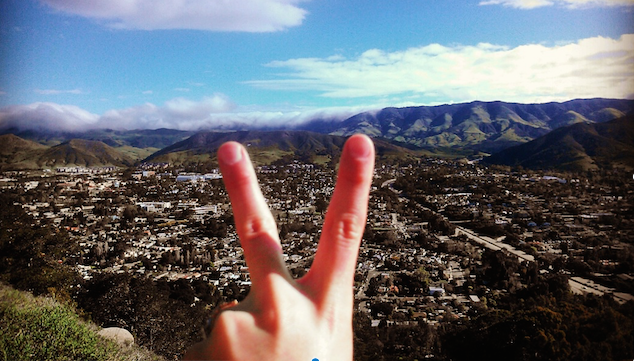 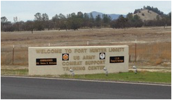 Approximately 1.5 hours north of San Luis Obispo, lies a granite playground to explore. By going across the Fort Hunter Liggett training grounds, you will access some pristine swatches of the Los Padres National Forest. At one time, shortly after 9/11/01, you had to pass through a security checkpoint to access this natural wonder. These days they've done away with the pat-downs, allowing you to pass by tanks firing, troops organizing, even a mini Baghdad (with flipped over cars, like a movie set) unimpeded by security forces. While you're passing through the Army base, you'll also have the opportunity to see Mission San Antonio de Padua, but that's for another article.

The San Francisco Bay Area encompasses many beautiful locations. Although the world famous Golden Gate Bridge is California’s most recognizable landmark symbolizing this area, and perhaps the state in general, the gorgeous nature scenery equally deserves to represent this expansive west coast state. Despite having interconnected urban cities, there are reclusive spots where you can reconnect with Mother Nature on hiking trails. Bear witness to sunsets painting evening skies; nature intermingling with urban borders; redwoods growing high until the eyes can’t distinguish the tops. If you are traveling to the San Francisco Bay Area region, and you’re an outdoor hiking fanatic, then it’s required that you partake in a hiking adventure trip to the five locations described below.
(Image: "Golden Gate Bridge at Night" art print. Click here to buy) |
San Luis Obispo BlogRegular WritersSarah Simon AboutWe look to provide ideas to get folks away from the couch, and out exploring California. We aim to provide day-trips. We want to provide suggestions of things to do, in a single day. Whether you're from out-of-town, or looking to get to know the our magnificent section of California (and beyond) a little better....we want to inspire you to explore. Categories
All
|
 RSS Feed